I went to Waterloo! And took lots of pictures!
The short version, or just a few thoughts re:Waterloo in order of appearance:
- Why is there a lion's butt in the middle of Wellington's line?
- Ridge, what ridge?
- This could be anywhere on european mainland, really. You have to know what you are looking at to know what you are looking at. These could be any fields, any where. All od Europe is blooded earth, has been for millenia.
I will not try to give an account of the battle, others do that much better. I just want to post some pictures of things that struck me as important to understand what was going on.
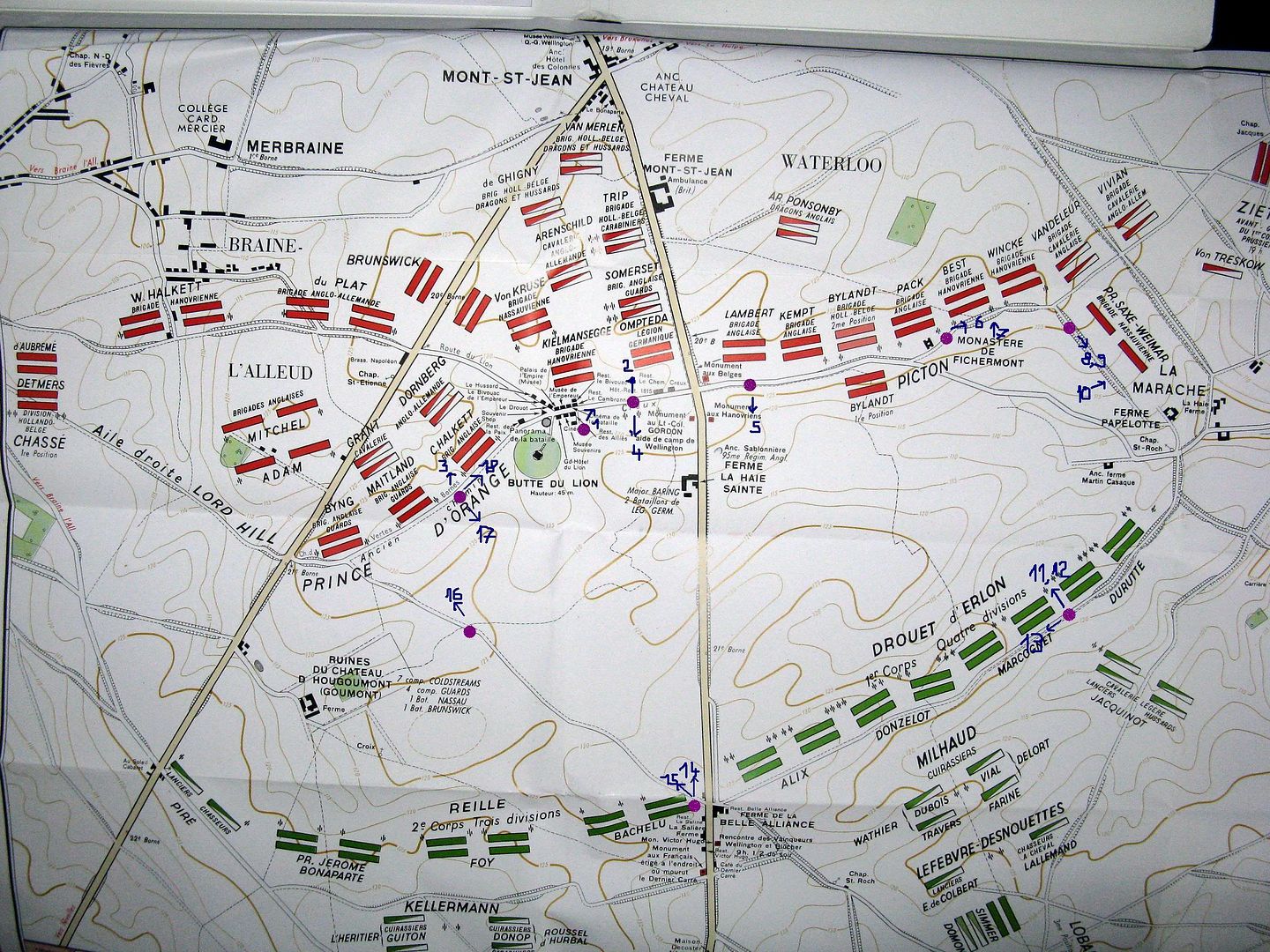
First this is a map of the battlefield (what are you laughing at?? Of course I have a map!)
After some searching I found Wellington's ridge; see the different height of the bank left and right of the road?

1 A lot of the ridge was used to built the dutch butt.
Then I had a look at the area behind the ridge, where Wellington had his men lay down to shelter from cannon and later form square to recieve cavalry. 2 left flank, 3 right flank


4And this is Wellington's view south, towards Belle Alliance

5Picton's view from the left flank

6The road on the ridge, left flank

7 and the french had to attack these hedges

The dutch butt is the Butte du Lion, rising 45m above the ground and, to quote Sharpiefan "It's where His Silliness the Prince of Orange got himself shot by his own side. He put the mound up as a monument...
...though a certain author likes to call it 'a monument to Dutch cowardice'!"
It's in the middle of the right/west flank:
The map again

The lion's butt in the background was built by scraping away some of Wellington's ridge. The ground used to be level with the base of the Gordon Monument in the front.
The sunken roads were important as well 8,9


Cavalry, trapped in the roads, was slaugtered from above
or, as a defensive position, infantry was fairly safe in their shelter.
10View out from the inside of a sunken road.

13Along this ridge Napoleon had placed 80 guns, their range: 1200m to Wellington's ridge.
View from french guns to english line 11,12 left flank, right flank


Remember how far back from Wellingtons ridge the woods in the background were?
left flank
right flank
The gunners and the attacking colums or cavalry could not see the redcoats.
*I'm getting the hang of this posting-thing*
don't get lost, have a map
14 Napoleon's view from Belle Alliance to Wellington's ridge. A lot of the ridge is the dutch butt nowadays...

15 and this is the view from Belle Alliance to the right flank. This is way Ney's cavalry charged

16 and finally, as I was biking toward Wellington's right flank, I realised: Yes, there is a ridge!

17 View from the ridge to Belle Alliance

18 along the ridge, right flank. Here infantry squares were charged by Ney's cavalry for 2 hours

Now I am back at the butt and covered in mud. I started the day in black boots and cargo pants. I'm nicely camouflaged now. Torrential rain in the night? check. Slogging through mud? check.
It must have been... I have no words.
The short version, or just a few thoughts re:Waterloo in order of appearance:
- Why is there a lion's butt in the middle of Wellington's line?
- Ridge, what ridge?
- This could be anywhere on european mainland, really. You have to know what you are looking at to know what you are looking at. These could be any fields, any where. All od Europe is blooded earth, has been for millenia.
I will not try to give an account of the battle, others do that much better. I just want to post some pictures of things that struck me as important to understand what was going on.
First this is a map of the battlefield (what are you laughing at?? Of course I have a map!)
After some searching I found Wellington's ridge; see the different height of the bank left and right of the road?
1 A lot of the ridge was used to built the dutch butt.
Then I had a look at the area behind the ridge, where Wellington had his men lay down to shelter from cannon and later form square to recieve cavalry. 2 left flank, 3 right flank
4And this is Wellington's view south, towards Belle Alliance
5Picton's view from the left flank
6The road on the ridge, left flank
7 and the french had to attack these hedges
The dutch butt is the Butte du Lion, rising 45m above the ground and, to quote Sharpiefan "It's where His Silliness the Prince of Orange got himself shot by his own side. He put the mound up as a monument...
...though a certain author likes to call it 'a monument to Dutch cowardice'!"
It's in the middle of the right/west flank:
The map again
The lion's butt in the background was built by scraping away some of Wellington's ridge. The ground used to be level with the base of the Gordon Monument in the front.
The sunken roads were important as well 8,9
Cavalry, trapped in the roads, was slaugtered from above
or, as a defensive position, infantry was fairly safe in their shelter.
10View out from the inside of a sunken road.
13Along this ridge Napoleon had placed 80 guns, their range: 1200m to Wellington's ridge.
View from french guns to english line 11,12 left flank, right flank
Remember how far back from Wellingtons ridge the woods in the background were?
left flank
right flank
The gunners and the attacking colums or cavalry could not see the redcoats.
*I'm getting the hang of this posting-thing*
don't get lost, have a map
14 Napoleon's view from Belle Alliance to Wellington's ridge. A lot of the ridge is the dutch butt nowadays...
15 and this is the view from Belle Alliance to the right flank. This is way Ney's cavalry charged
16 and finally, as I was biking toward Wellington's right flank, I realised: Yes, there is a ridge!
17 View from the ridge to Belle Alliance
18 along the ridge, right flank. Here infantry squares were charged by Ney's cavalry for 2 hours
Now I am back at the butt and covered in mud. I started the day in black boots and cargo pants. I'm nicely camouflaged now. Torrential rain in the night? check. Slogging through mud? check.
It must have been... I have no words.